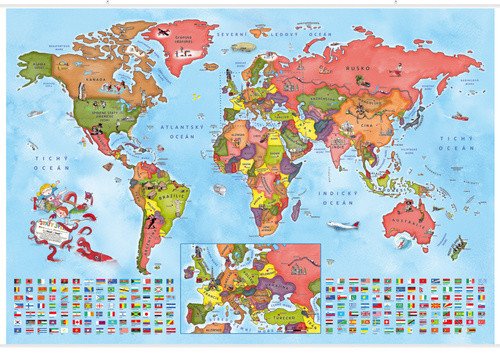

Beschreibung
Möchten Sie, dass Ihr Kind im Schul- oder Vorschulalter die Länder der Welt immer im Blick hat und sie auf spielerische Weise kennenlernt? Dann gibt es keine schönere Dekoration fürs Kinderzimmer als unsere illustrierte Weltkarte für kleine Weltenbummler. Wie Sie vielleicht schon von unserem illustrierten Atlas wissen, beschlossen die achtjährigen Zwillinge Anička und Kryštof eines Tages, einen Weltatlas für kleine Abenteurer wie sie selbst zu erstellen. Sie begaben sich auf eine lange Reise, auf der sie alle Kontinente besuchten und ihre Erlebnisse und ihr Wissen mit Gleichaltrigen in Form von faszinierenden Illustrationen, einem Reisetagebuch und weiteren Notizen teilten. Doch damit nicht genug. Nach ihrer Rückkehr nahmen sie eine politische Weltkarte, auf der alle Länder verzeichnet sind, zeichneten sie im Wandkartenformat neu und markierten alle Sehenswürdigkeiten, Städte, Verkehrsmittel und Bevölkerungsgruppen, denen sie begegneten. So entstand eine wunderschöne, übersichtliche und gut lesbare politische Weltkarte, die Kindern nicht nur die Lage der Länder zeigt, sondern auch die interessanten Besonderheiten verschiedener Regionen hervorhebt. Um möglichst viele Informationen aus der Karte zu gewinnen, schlagen Sie den dazugehörigen illustrierten Atlas auf. Darin erfahren Sie, was jedes Bild darstellt. Alles ist aus der Perspektive von Kindern geschrieben und illustriert – klar und ansprechend.
Information
Language: Czech
Publication date: 1. Juli 2023
Manufacturer: KARTOGRAFIE Praha, as
Genres: Karten und Reiseführer, Schulatlanten und Karten, Bücher, Reisen, Lehrbücher und Sprachen
Type: Karten und Atlanten
ISBN/EAN: 8594033222673